Broad Street Live Oak Project

Broad Street Tiger Project Tree by Tree Assessment Report

Submitted by the Government Street Collaborative (GSC) on May 15, 2019 to the City of Mobile.

Background and Timeline of Events:

In 2016, the City of Mobile was awarded a $14.5 million Tiger Grant from the U. S. Department of Transportation for the The Broad Street Corridor Project, a much needed revitalization of Broad Street. The project’s goals included connecting neighborhoods and downtown commercial interest to several transportation modes including bus, rail, plane as well as adding bike lanes and rebuilding sidewalks. Given the inferior and unsafe condition of the existing infrastructure, the reinvention of Broad and Beauregard has been met with great excitement and enthusiastic support from neighborhood residents, businesses and those who work downtown.

Three public meetings were held, one in 2016 and two in 2017 seeking comments and feedback from area residents.

• From August 2017 (the date of the last public meeting) until February 19, 2019 (date of a Tree Commission Meeting) very little new information was supplied to the public about the project.

• At that February 2019 Tree Commission meeting, the City of Mobile requested the removal of 55 trees, the majority of which were Live Oak Trees, on the Broad Street Corridor. During the meeting, it was learned the Tree Commission had previously, on October 17, 2017, approved the removal of 43 trees, again the majority of which were Live Oaks, along Broad and Beauregard. This was the first indication from the City to the public of the need to remove Live Oaks in large numbers and came as a surprise to many residents who see the Live Oak as an icon of the city. Representatives of the GSC along with other citizens requested a delay in the Tree Commission’s decision, to allow more public discussion and input, but the request was denied based on the City’s insistence that a delay in the decision would threaten the Tiger Grant funding.

• The following Tuesday (February 26, 2019) the GSC brought to the attention of the Mobile City Council and to Mayor Stimpson its great concern over the number of Live Oaks being removed and requested a public forum to ask questions and express concerns. Mayor Stimpson offered to meet with up to 10 neighborhood representatives to discuss the issue and upon the advise of the City Council, the GSC appealed the Tree Commission decision.

• On March 8, the Mayor met with the neighborhood representatives and agreed to save up to 5 Live Oaks slated for removal and to include up to 7 Live Oaks as replacement trees in other locations along Broad. See Attachment:

• As a result of the appeal, a public hearing was held during the City Council’s regular meeting on March 19th. During that meeting, an agreement on several points was reached with the Mayor’s staff resulting in a letter dated March 29, 2019 (see attached) from Mayor Sandy Stimpson. The Mayor’s letter stipulated three main areas of agreement:

1) A tree-by-tree assessment to determine the feasibility of eliminating some parking spaces for existing healthy trees where utilities and drainage allow;

2) The collaboration on a mitigation plan in conjunction with Urban Forestry, the Government Street Collaborative, and private owners on the corridor as well as other neighborhood groups near the corridor that would encourage additional plantings on private property near the corridor;

3) To the extent possible, a planting within the roundabout at Canal and Broad, preferably a Live Oak tree.

During the month of April, the GSC formed four teams to do a the tree-by-tree assessment sending the teams out to walk Broad and Beauregard Streets to find possible tree candidates that could be swapped for parallel parking spaces. Several possible tree candidates and situations were considered. The below submissions are categorized in two groups.

Group A (Parallel Parking Swap for Live Oaks) are situations where an existing Live Oak or replacement Live Oak could be swapped for parallel parking spaces.

Summary:

• Total number of parallel parking spaces requested to be removed for planting: 10

• Total number of Live Oaks requested planted in exchange for parking: 7

Group B (Planting of Live Oaks at Major Intersections) are situations where Live Oaks could be planted or existing Live Oaks could be saved near major intersections.

Summary:

• Total number of Live Oaks requested to be planted or saved near intersections 5

Grand total of requested Live Oaks to either be saved or planted: 12

Separate reports shall be submitted on the proposed mitigation plan with private owners and on the planting of a live oak in the roundabout at Canal and Broad.

Group A

Parallel Parking Swap for Live Oak

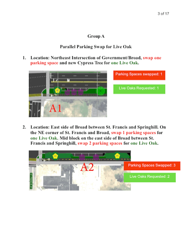
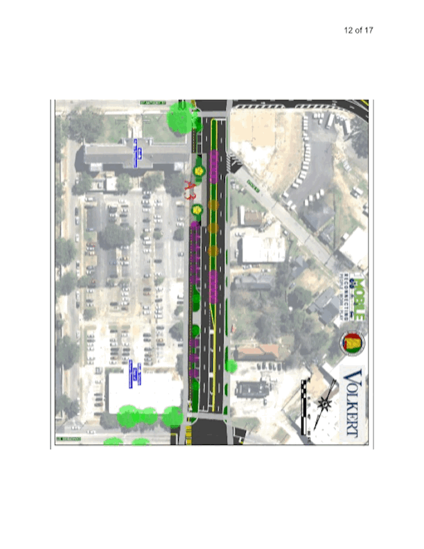
1. Location: Northeast Intersection of Government/Broad, swap one parking space and new Cypress Tree for one Live Oak.

2. Location: East side of Broad between St. Francis and Springhill. On the NE corner of St. Francis and Broad, swap 1 parking spaces for one Live Oak. Mid block on the east side of Broad between St. Francis and Springhill, swap 2 parking spaces for one Live Oak.

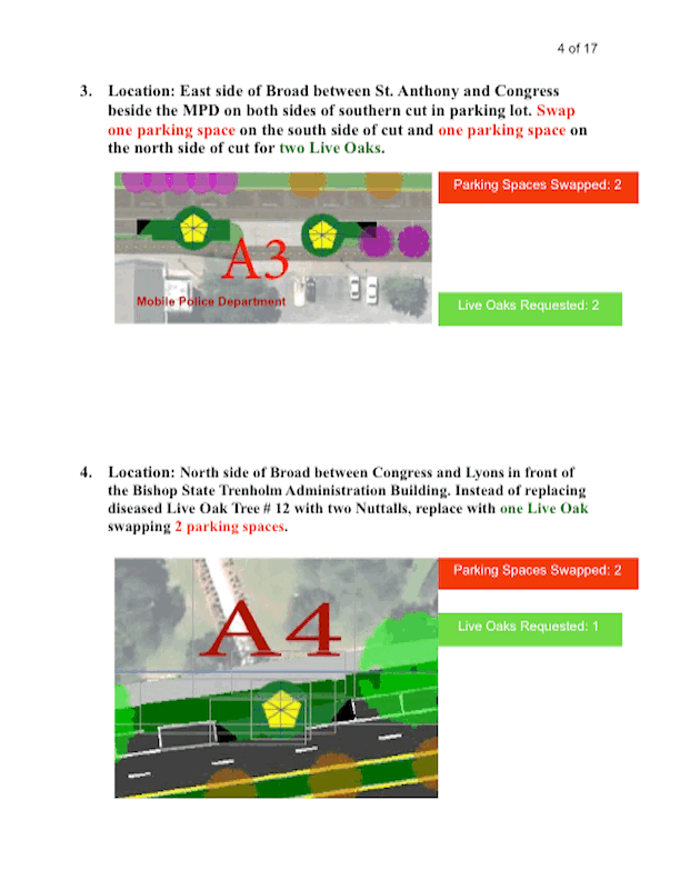
3. Location: East side of Broad between St. Anthony and Congress beside the MPD on both sides of southern cut in parking lot. Swap one parking space on the south side of cut and one parking space on the north side of cut for two Live Oaks.

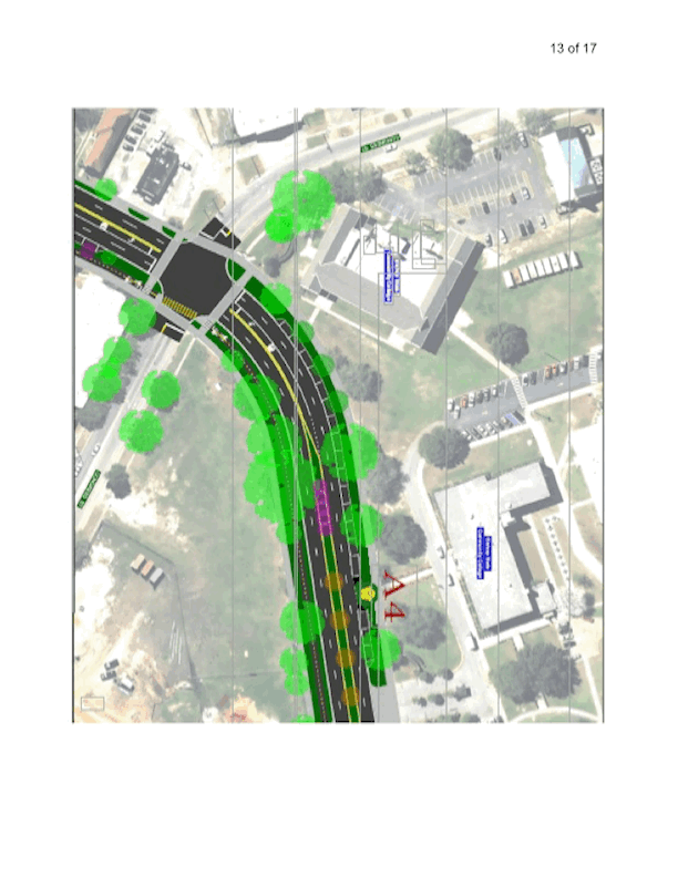
4. Location: North side of Broad between Congress and Lyons in front of the Bishop State Trenholm Administration Building. Instead of replacing diseased Live Oak Tree # 12 with two Nuttalls, replace with one Live Oak swapping 2 parking spaces.

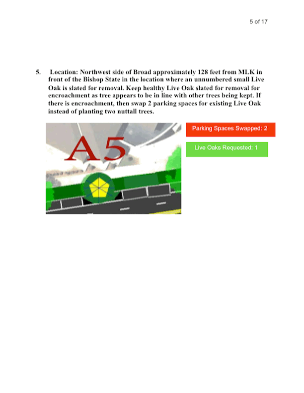
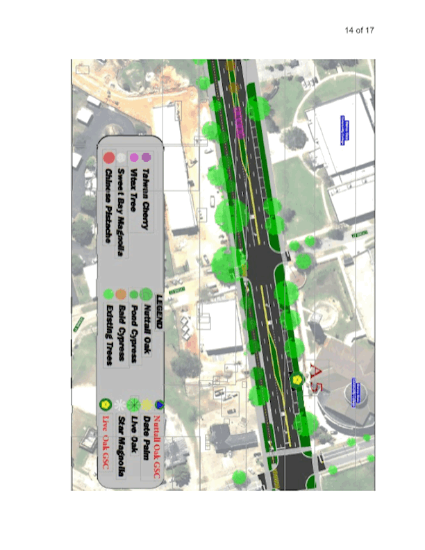
5. Location: Northwest side of Broad approximately 128 feet from MLK in front of the Bishop State in the location where an unnumbered small Live Oak is slated for removal. Keep healthy Live Oak slated for removal for encroachment as tree appears to be in line with other trees being kept. If there is encroachment, then swap 2 parking spaces for existing Live Oak instead of planting two nuttall trees.

Group B

Adding Live Oaks at Major Intersections

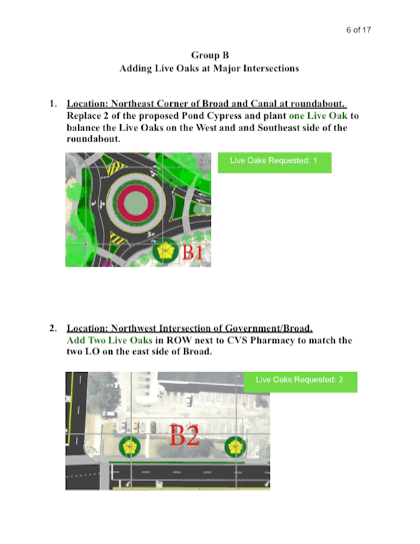
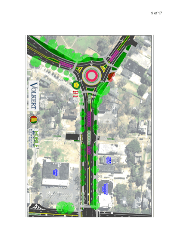
1. Location: Northeast Corner of Broad and Canal at roundabout. Replace 2 of the proposed Pond Cypress and plant one Live Oak to balance the Live Oaks on the West and and Southeast side of the roundabout.

2. Location: Northwest Intersection of Government/Broad.

Add Two Live Oaks in ROW next to CVS Pharmacy to match the two LO on the east side of Broad.

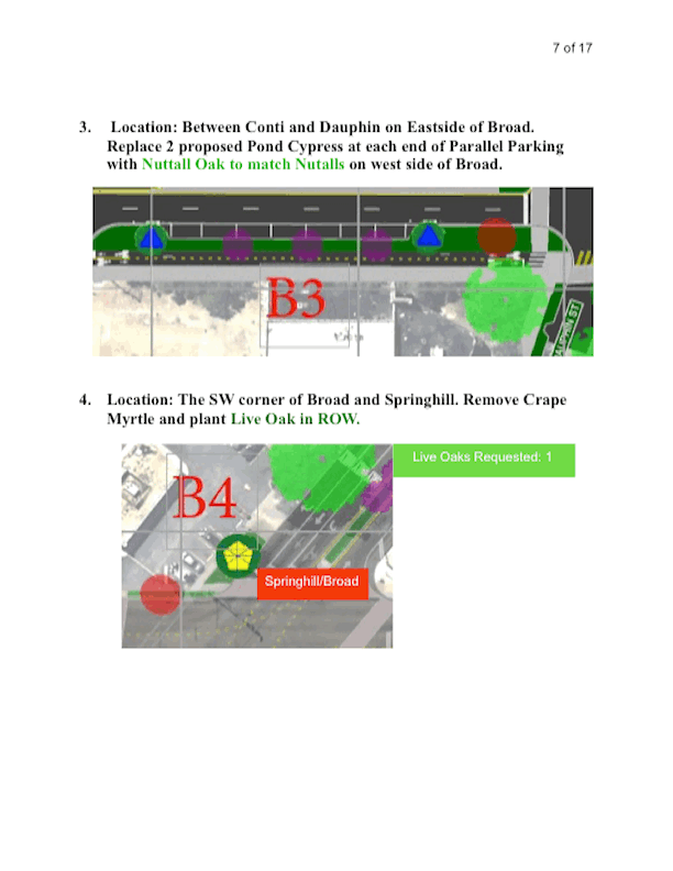
3. Location: Between Conti and Dauphin on Eastside of Broad. Replace 2 proposed Pond Cypress at each end of Parallel Parking with Nuttall Oak to match Nutalls on west side of Broad.

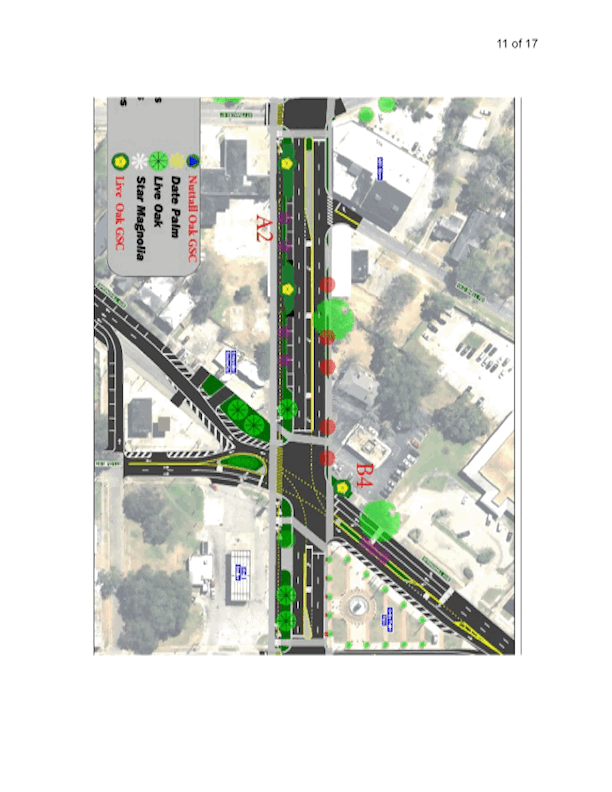
4. Location: The SW corner of Broad and Springhill. Remove Crape Myrtle and plant Live Oak in ROW.

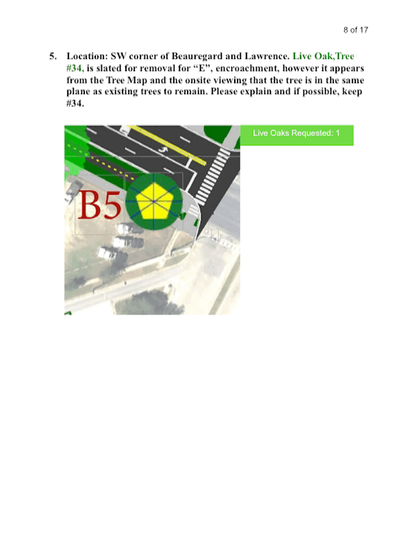
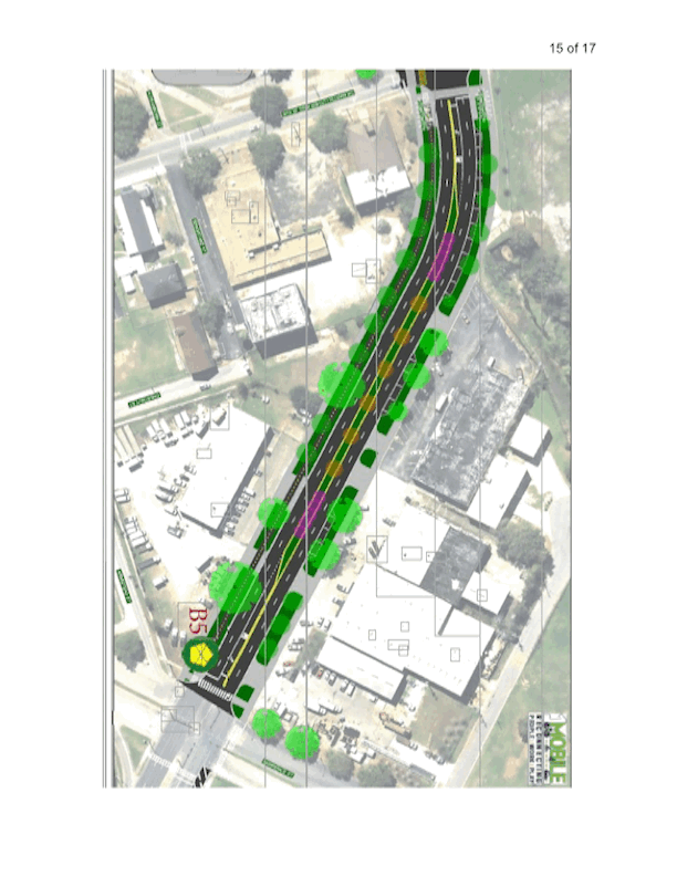
5. Location: SW corner of Beauregard and Lawrence. Live Oak,Tree #34, is slated for removal for “E”, encroachment, however it appears from the Tree Map and the onsite viewing that the tree is in the same plane as existing trees to remain. Please explain and if possible, keep #34.

[SCROLL TO MAPS BELOW SHOWING RECOMMENDED LIVE OAK SELECTIONS - GROUP A RECOMMENDED LIVE OAKS SHOWN AS A YELLOW PENTAGON; RECOMMENDED NUTTALL OAK SHOWN AS BLUE PYRAMID. SEE CITY DESIGNATIONS IN LEGEND ON PAGE 10 OF 17]

Slide03.gif
Slide04.gif
Slide05.gif
Slide06.gif
Slide07.gif
Slide08.gif
Slide09.gif
Slide10.gif
Slide11.gif
Slide12.gif
Slide13.gif
Slide14.gif
Slide15.gif

GSC Letter to Mayor, District 2 Councilman Manzie, City Administrators re: Tiger Grant

The member groups and individuals of the Government Street Collaborative have communicated following the recent Tree Commission vote to approve the removal of 55 trees, in the plan for the One Mobile Tiger Grant.  Most feel there was a lack of important information disseminated throughout the planning stage and better public information is now needed, regardless of the outcome of the Tree Commission vote or any appeals that may follow.  Toward that end, my purpose here is to join others in requesting a public forum on the grant.  Our hope is that a successful forum along with cooperative key city staff under the administration’s guidance could result in a better plan that could set a more positive precedent for the remaining grant phases, as well as future city planning, such as the pending Bienville Square or other plans.  


Most of our members were represented at the early Grant public informational meetings through August, 2017, and were enthusiastic for a plan to address the connections lost over time in our city to ill-planned expansion. Building on the earlier Bring Back Broad initiative, the One Mobile Grant promised to reconnect Mobilians to the new 3 Mile Greenway, to the transit services at the GM&O, to the Brookley complex, and most importantly, to reconnect neighborhoods from north to south and east to west.  No longer, the grant promised, would Broad Street serve to block and disconnect our people by running an unsafe 8 to 11 lane urban roadway through the heart of Mobile.  Now, it envisioned, Mobilians would walk, drive, and bicycle to destinations on a redesigned, safe, multi-modal  “complete street.”  That complete street would be pedestrian and bicycle friendly, would have been reduced by half to 2, 3, or 4 auto lanes to serve needs in different segments, while providing added pedestrian and bike paths.


Naturally, a vast majority of Mobilians loved the vision and goals presented, and their acceptance was further captured by the promise of “enhanced landscaping”  to enrich the Broad Street aesthetic experience.


At no time in those early meetings, nor in the grant narrative made available, was there mention of removal of dozens, perhaps over 100, of mature and largely healthy heritage live oaks.  In fact, quite the opposite, as illustrations in the grant clearly promise an abundance of large tree shapes, though the species are not identifiable in the diagrams. The “features” in the grant narrative specifically promise “street trees.”  


Further, the landscape plan presented to the Tree Commission, when made available upon request, generated an enormous number of questions and concerns, as it appears to have altered the original plan presented for public input. This is perhaps at least in part because of changes in the state tree law, which undercut the Tree Commission authority and the protections offered.


It would be helpful if the city could arrange a public forum to address these issues prior to the appeal deadline.  I am uncertain to whom this request should go, so I am sending it to several city administrators and the Mayor, as well as my Councilman. Further, a Collaborative member will speak at the Council meeting on this Tuesday, February 26, and will join this request for a public forum hosted by the city.


I hope you are able to address this request or route it to others who can. Thank you for your work with our city.


CC:     Mayor Sandy Stimpson, City of Mobile

          Councilman Levon Manzie

Ms Shayla Beaco, Build Mobile Director

        Nick Amberger, City Engineer

         Peter Toler, City Arborist

A Letter from the Leinkauf Board for the Board of Adjustment May 6 Meeting regarding the 1400 Church Street apartment development

A statement by the LHDNO Board: [read into the record of the May 6 Board of Adjustment meeting by a Leinkauf resident. [Note: The Board of Adjustment decided in favor of the neighborhood in a compromise for a rental limited to a density of 6 units, which existing parking will support under existing Code.]

  1. At the February LHDNO community meeting, members who had received the city’s public notice regarding the 1400 Church St development attended and brought copies of the public notice and asked that the President announce the development, which he did.  In the ensuing discussion, there were many questions but no outright support for the project, pending further information.

  2. The President and Board contacted the developer and arranged a neighborhood meeting and the developer attended.

  3. Following that meeting, neighbors expressed that there were too many remaining concerns and voiced those to the President and some Board members.

  4. The President formed an Ad Hoc committee to again meet with Mr. Jackson.  At that meeting, he listened to the concerns and accepted a sample design from the committee which would have been for only 5 units, but larger units which could bring him more monthly rent while offering the district a more stable rental client base than small studios will produce.

  5. Mr. Jackson mentioned that his market was transient workers and he would likely require a shorter than one year lease, probably 6 month.

  6. At the end of the Ad Hoc Committee Meeting, Mr. Jackson said he would consider the alternate plan.

  7. Later, the LHDNO Board learned he may reduce the project from 10 to 8 units, which remains an overly dense development in that location, which will be explained below.

  8. The Board has since let it be known they would accept a 5 or 6 unit development of larger apartments more likely to bring a more stable renter base and also meet the city’s  1.5 parking space per unit standard and reduce the issues related to street parking on a  residential street fronting Leinkauf Elementary School.

9.   At this time, and because Mr. Jackson has not committed to a 5 or 6 unit development, the  LHDNO Board cannot support the development.

10. In addition, Board members have spoken to a number of immediately surrounding neighbors, most likely impacted, and none support an 8 or 10 unit plan, and one submitted a letter to be read today.

11.  The LHDNO Board wishes to emphasize it does not object to a good rental plan but objects only to the 8 or 10 unit proposed density.

12.  The Board’s objections are based on:

       a.  The city’s 6 to 10 unit per acre density standard for MxDR or mixed use residential zones, keeping in mind this property is far less than 1 acre.  

       b.  Almost adjacent to this property, and within one acre’s space, are two other apartment buildings facing Everett, and the combined density of those with this building will be far beyond the 10 unit per acre density standard.  This will not do justice to the surrounding neighborhood, failing to protect R1 zoning standards.

       c.  The fact that 10 units was approved a decade ago is irrelevant to this approval, as that approval lapsed due to over a 10 year vacancy period.  It was approved during the worse recession seen since the 1930’s  and the circumstances of that time in 2010 are  completely different and should not be evaluated the same.  It should further be noted that LHDNO is not objecting to rental property but only to the density which will result from this plan.

       d.  Further, that approval was apparently for a church to install some type of emergency barrack style housing, which is no longer the case and is not appropriate to the historic district in which the building is sited.

        e. The parking is not adequate for 8 to 10 units which will result in street parking on a  residential street fronting school property where increased traffic  as well as the  school children’s foot traffic will  create traffic flow problems at take-in and dismissal.

         f.  Finally, this parcel is zoned R1 and is surrounded by R1.  The fact that it once operated as multi-family in the distant past—over 15 years ago —should not sway the Board to approve this application. To approve it at this time does not do justice to the surrounding neighborhood.  The lapse of approvals after a 2 year vacancy exists for a  reason, and that reason is to honor the ways in which neighborhoods change.  In this instance, there is no denying that Leinkauf is in an improvement trend with desirable single family housing becoming more marketable.  Your decision here today can support a trend that will ultimately bring a more stable district to the city and justice to the surrounding neighborhood.

        For these reasons, the LHDNO Board welcomes Mr. Jackson’s rehab of this building and offers him our support — but only if Mr. Jackson will submit a 5- or 6-unit maximum plan for this development.


GSC letter to Planning, Feb. 2018

SEE THE LETTER BELOW OF  COMMUNICATIONS WITH MS BEACO AT THE PLANNING DIVISION AS OF FEBRUARY 6.

TO: Ms. Shayla Beaco

Thank you so much for taking the time to speak with me regarding the ongoing revision of the City of Mobile Zoning and Ordinances. This is to serve as a summary of our conversation and a suggested plan forward to facilitate continued community input into this process. Many of the community constituent groups would like an opportunity to meet with you, your staff and Mark White to get an update on the progress and to address additional questions/concerns. You indicated that Mr. White is in communication with you and your department but will not return to Mobile until March. We want a meeting to include all the parties so we agreed to wait until his return. 

It was suggested that we submit our questions to you directly or through the form on the city website and that you will answer them in writing prior to the release of the first draft. We are in the process now of developing a list of outstanding and/or new questions from individuals in our circles of influence including a review of past questions and responses posted on the website. We will consolidate them and forward them to you for your written answers in anticipation that some of them might affect changes/additions to the first draft. Prior to submission to the Mobile Planning Commission, the City’s planning staff will release the final draft of the new zoning ordinance to the Zoning Technical Advisory Committee as well as to the general public for review and comment. It is the plan to circulate this draft for roughly 30 days before submission to the Planning Commission. This 30 day time period will allow staff the necessary time to address any additional feedback or input from the technical advisory committee, community stakeholders, and the general public.

We will wait to have our meeting with you and Mark White until after the release of the first draft so that any further questions/concerns could be addressed. It is our suggestion further that we will provide you with written questions prior to that meeting. Many of us have attended all of your presentations and are familiar with the broad presentation. Our plan is that this meeting will provide concrete answers to concrete questions and concerns. By providing them prior to the meeting, this will allow you time to have the answers available at the meeting. 

When you have a date certain for the release of the first draft for citizens' perusal, you will let us know so that we can secure an appropriate venue for a meeting. Obviously when a group venue is necessary, I am sure you understand that we need adequate lead time. Please let me know if I have omitted or misrepresented anything from our telephone conversation. As I stated to you at that time, we really appreciate all the work that you and your staff are putting into this huge, very important project.

GSC Submits Comment on Nonconformities

I

Article 7 Nonconformities of Uses, Lots, Structures, Sites

Input Statement from the Government Street Collaborative

Because most of the language in the Nonconformities section was pulled in from the current Ordinance or the DDD, it is familiar and addresses most concerns. The GSC comments that this rewrite is an opportunity to improve health, safety, and the general welfare, by bringing it closer to the vision of Map for Mobile. Therefore, we ask the following questions and make the following comments:

1. Is it a correct interpretation of Table VII -1 that allowing a change from one nonconforming use to another nonconforming use, has the intent of only allowing a change that reduces the intensity of use?  The language of this table is open to misinterpretation. In no case should a nonconformity change to a more intense  nonconformity. Further, any change to a nonconformity use, lot, site, or structure should require an application and approval process as a Conditional use approval.

2. Expansion of nonconforming structures: “may expand on land owned.”

What is the actual intent here? If it is to allow expansion to other land/lots owned, GSC requests clarity: “may expand on contiguous land owned” or “land owned with shared adjacencies” or “only within the premises.” The point being an expansion on a disconnected lot should be disallowed or considered a new nonconformity. Could also be addressed by defining a “new nonconformity” to include one established on a separate, noncontiguous parcel of land owned.

3. Abandonment of Nonconforming structures/lots/uses: The 2-year rule is in use now. However, in light of the Map for Mobile goals of elevating quality of life through safer neighborhoods, and what we know of crime and safety hazards on abandoned properties, we ask that our Zoning law provide for our health, safety and general welfare by reducing the abandonment period to one year, with an appeal option for an additional year. This is consistent with the 1 year timeline for repairing nonconforming structures.

GSC Submits Follow-UP to Previous Questions and Responses

FOLLOW-UP TO PREVIOUS RESPONSES: THE GSC TOP FIVE

from The Government Street Collaborative

In preparation for the full First Draft and a March meeting with the GSC and Planning,the GSC has reviewed all previous questions and city responses. We appreciate thetransparency and accessibility to information you have provided. We also recognizethat some of our lingering concerns may yet be addressed in the full draft and/or theLand Use and Zoning Maps when published. it is important that we receive the actualMaps with time for review. We want to continue to emphasize those areas of greatest community concern and any responses which either leave or create continued questions. Toward that end, the GSC has consolidated community input into these five areas:

I. Uses that are inappropriate for, or too intense for, the Government St CT. See page 2 below, I Uses, for details.

II. Language which undercuts “standards” and diminishes the Map for Mobile long range planning Vision, by inviting development that— a) is overly flexible-creating a “moving target” for our neighborhoods, b) is driven by short-term market whims not anchored to that Vision, c) allows as part of the Ordinance the type of variances normally reserved for BOA and/or Council decisions, and d) sometimes alludes to a need for new “policy” that would have the effect of diminishing the strength of regulations, such as limits to nonconformities See Page 3 below, II Standards

III. The need for a mechanism such as a Government Street Overlay which recognizes and protects the unique residential character of Government Street.  See page 5 below, III Recognizing and Protecting the Residential Character of Govt St.

IV. Inaccurate representation in city responses of how hazardous substances and intensive manufacturing using hazardous substances are treated in the Chart of Permitted Uses. A citizen was told that his submission was “incorrect.” However, it was certainly correct, and this response on the website should be changed and corrected. These uses have never been permitted “by right” but are now permitted “by right” on the new chart of uses, as the citizen submission correctly states. See Page 6 below, IV Hazardous Substances

V. Many earlier submissions were responded to as “under review,” “in discussion,” “Considering Maritime District,” etc. We ask for any of these which have now been finalized to be provided. Of special interest to the GSC are: Those impacting historic districts and Government Street specifically — especially Uses, the DW\district and heavy industry development downtown.  Some of these may be resolved when the new FLUM or actual Zoning Maps are released, and the GSC emphasizes the importance of those maps being available for review prior to characterizing the project a "final" or taking the Ordinance to any body for approval.


DETAIL: GSC TOP FIVE CONCERNS EXPANDED WITH DETAIL

I. USES

A.

The Government Street Collaborative member groups and local residents continue to

take the position that the uses listed below can have significant and negative

effects in historic neighborhoods (-namely Residential Mixed, Traditional

Corridors, Neighborhood Centers, and Downtown ) - and should be

disallowed OR conditionally allowed in these areas only after public

input and review by the Planning Commission and the City Council:

Apartment Homes, Rooming and Boarding House, Community Residential

Facility , Residential Care Facilities, Community Housing, Hotel/Motel, Bar/

Lounge, Drive-thru Restaurant, Day Labor Services, Convenience Store,

Gasoline Fuel Sales, Car Wash, Social Welfare and Charitable Services,

Hospital, Medical or Dental Clinic, Parking Facility , Minor Utility , Teen Club

City Response: Under staff review for further consideration.

Question: Current Status of these Uses?

B.

THE GSC REQUESTED THAT CONVENIENCE STORES WITH GAS SERVICE AND CAR

WASHES NOT BE PERMITTED IN THE GOV’T ST CT DUE TO INAPPROPRIATE

DESIGN AND IMPACT CONCERNS.

CITY RESPONSE: What design and impact concerns would entIrely disqualify

these in CT?

SEE GSC CONCERNS BELOW:

MOBILE HAS DEVELOPED WITH SOME UNIQUE TRADITIONAL CORRIDORS THAT

ARE HISTORIC IN NATURE, RETAINING A LARGELY RESIDENTIAL CHARACTER

(SUCH AS GOVT ST AND DAUPHIN ST) AND WHICH SUPPORT ADJACENT

HISTORIC DISTRICTS. THE CONVENIENCE STORE with GAS STATION AND CAR

WASH ARE NOT IN KEEPING ON GOVERNMENT STREET. TYPICAL INAPPROPRIATE

DESIGN ELEMENTS AND IMPACTS FOR SUCH BUSINESSES INCLUDE:

*LOW PROFILE BUILDINGS THAT ARE OUT OF SCALE WITH THE STREETSCAPE,

*EXPOSED AND UNAPPEALING STALLS ALONG STREET FRONTAGE ON ONE OR

MORE SIDES, sometimes fronting a residential side street.

*SHORT-LIFE METAL BUILDINGS WITH MATERIALS AND COMPONENTS THAT

BECOME A DANGER TO SURROUNDING PERMANENT PROPERTIES IN STORMS

*GAS TANKS OR WASH STALLS ALONG FRONTAGE, CREATING AN UNAPPEALING

FACADE FOR OUR HISTORIC AREAS

*OFTEN GARISH COLORS, GRAPHICS, AND LIGHTING THAT, IF CHALLENGED,

PURPORT TO BE NECESSARY TO BUSINESS MARKETING IDENTITY (GSC

HAS ASKED THIS TO BE ADDRESSED IN THE SIGNAGE MODULE AND REGULATED

AS SIGNAGE)

*NOISE and TRAFFIC NUISANCE

*CARRY OUT LIQUOR SALES, AND

*INCREASED CRIME STATISTICS (ARMED ROBBERY).

2

GOVT ST AS A STATE HWY ALLOWS ONLY ONE CURB CUT SO HIGH TRAFFIC

FLOW IMPEDES THE MAIN FLOW OF TRAFFIC ON GOVT ST. OR ELSE REQUIRES A

CURB CUT ONTO A RESIDENTIAL SIDE STREET PERPENDICULAR TO GOVT ST.—

NOT ACCEPTABLE!  ALMOST ALL GOVT ST FRONTAGE PARCELS BACK UP TO RESIDENTIAL

HOMES ON AT LEAST ONE SIDE, PLACING THE CONVENIENCE STORE/GAS OPERATION/

CAR WASH IMMEDIATELY ADJACENT TO PRIVATE HOMES.

FURTHER, THERE ARE ALREADY CONVENIENCE STORE/GAS STATION/CAR WASH

PARCELS ZONED AT MAJOR NODES: AT ANN STREET, AT MICHIGAN AVE, AT

DAUPHIN ISLAND PARKWAY, AT MEMORIAL AND PUBLIC SAFETY PARKS. SINCE

ZONING RUNS WITH THE LAND, THESE WILL BE GRANDFATHERED AND ARE

ADEQUATE TO SERVE THE AREA NEIGHBORHOODS AND PASS THROUGH TRAFFIC. IN

ADDITION, THERE ARE NUMEROUS FOOD STORES AND PHARMACIES OFFERING LIMITED

CONVENIENCE FOODS AND HOME OR CONVENIENCE ITEMS. FINALLY, THERE ARE 4 CAR

WASHES BETWEEN MEMORIAL PARK AND DIP. ANY SATURATION OF A SNGLE TYPE OF

COMMERCIAL DEVELOPMENT THREATENS THE VIABILITY OF AN AREA AND

DISCOURAGES THE KIND OF VARIETY THAT SUPPORTS NEIGHBORHOOD NEEDS. SUCH

[new] FOOD/GAS/CAR WASH DEVELOPMENTS ARE UNNECESSARY AS WELL AS

UNDESIRABLE ON GOVT ST. THE ANSWER TO THIS AND OTHER SUCH SITUATIONS SEEMS TO

LIE IN A NEED FOR A GOVT ST OVERLAY, SINCE ALL CT’S DO NOT SHARE THESE

CHARACTERISTICS, AND THAT IS WHAT THE GSC AND ITS HISTORIC DISTRICT MEMBERS

REQUEST.

II STANDARDS that are undercut by overly flexible language and procedure:

“Limited application” and “market conditions” and need for “more flexible

intensity” are examples of this language.

The GSC continues to question why the design and site standard charts and illustrative

examples repeatedly state that examples, though inappropriate in design for CT or

NCT, have “limited application” in CT, and NC areas.

The city response was: "Limited application" is only guidance for applying the zoning

designations, but does not suggest that someone in a district that requires a Type C

building type or Type 3 site design can use a Type D building type.

GSC Followup: If it does not suggest that, why is it so stated? If ”Limited application"

is only guidance for applying the zoning designations, but does not suggest that

someone in a district that requires a Type C building type or Type 3 site design can use

a Type D building type, why is the “limited application” language even necessary? It is

not necessary to reduce nonconformities, since all existing designs are grandfathered.

“Limited application” would seem to simply be a way to allow a type of design/lot/site/

3

use development which does not really fall within the CT standards. Why have

standards if the very language of the standard begins with such exceptions.

GSC asks the language “limited application” and the non-standard application

examples be removed . There is a Board of Adjustments for special exceptions that

are legitimate…GSC requests that we insure that the ordinance itself NOT become

a vehicle for facilitating exceptions. This language (“limited application”) does not

clarify, but rather clouds, intent.

A citizen submission questioned Article II, states: “Purpose: the standards in this

Article balance Map for Mobile’s design policies with market conditions and the need

for flexibility,” The City Response was: This section reflects the intent to provide *, if

more rigorous site and building design standards are met by a development project.

Real estate market conditions, along with the development potential allowed and

additional costs imposed by zoning and related external factors, will dictate the

anticipated return from a development project. If the applicable zoning regulations

allow for a higher rate of return on investment, it is conceptually possible for a project

to incorporate higher standards for building design, architecture, site amenities, and

associated infrastructure. Conversely, it would not be financially feasible to achieve

higher design standards on a project site if zoning regulations represent a burden with

respect to allowable density and intensity. This is why the composite standards

provide for customization of the use, building and site regulations based on a site’s

context and the Future Land Use Map.

GSC Comment: The GSC is very concerned about this degree of flexibility. It would

seem that if a certain density or intensity is already appropriate to a setting*, no such

flexibility should be needed. If not appropriate to a setting, why would we encourage it

or even allow it, particularly as an administrative decision, or outside of any process

that would allow public knowledge, review and input? Any such “flexibility” must occur

through a application and review and public hearing procedure.

A Zoning Ordinance should be a stable, long term document that guides a city’s future.

Market conditions, on the other hand, are short-term, even volatile, and using such

criteria erodes the long-term benefits of planning. A city that allows development to be

driven by short term market trends sacrifices its Vision for the future. A perfect

example of the result can be seen in the degradation of Government Street. In the

booming era of suburbanization and the automobile of the 1960s, market conditions

invited the destruction of valuable historical assets, replacing them with cheap, short

term fast food buildings, drive thru business, and strip mall centers. One decade of

“marketing conditions” destroyed over a hundred years of stable, long range

development of value. We almost lost our city in the process. It is undeniable that long

term, value-added planning is incompatible with short term conditions, and to facilitate

this incompatibility is counter to Map for Mobile.

4

And here is the bottom line: A historic property, once lost, can never be regained.

Since zoning runs with the land in Alabama, when we change a parcel to meet a short

term market condition, we place long term asset value at risk.

III  Recognizing and Protecting the Residential Character of Government Street

IN AN ANALYSIS OF 2017 TAX RECORDS FOR 147 GOVT. ST. PARCELS BETWEEN

BROAD AND MEMORIAL PARK, FEWER THAN 10% OF PARCELS ARE COMMERCIAL,

YET ALMOST 50% ARE RESIDENTIAL! ONE CANNOT SEE THIS STATISTIC AND DRAW

THE CONCLUSION THAT GOVT ST IS NOT RESIDENTIAL. FURTHER, ALMOST EVERY

FRONTAGE PARCEL ON GOVT ST IS ADJACENT TO A PRIVATE RESIDENCE ON AT

LEAST ONE SHARED LOT LINE.

A search of public records has revealed over 45 parcels in the 1.7 miles between

Broad and Houston Streets which have a more intense zoning on paper than is

actually in use on the ground today, and almost 20 of those are currently residential,

though zoned more intensely. 45 parcels change the face of a corridor.

In addition to over 45 parcels used at lower intensity than zoned, the GIS zoning map

reveals the following:

77 parcels in total are used Residential -

51 zoned and used as residential;

16 used asR1 but zoned more intensely

3 Limited B2 parcels at a NC

1 B3 on a residential corner but used only as retail and B1

48 B1 fronting Government with residential adjacencies

34 B2, but of those, research reveals 17 are used less intensely than B2, so only

17 parcels actually require the designated B2 zoning assigned

6 zoned and used Residential Business, low impact use in preserved historic buildings

7 Churches

Of these 176 identified parcels,

43.7% are currently in use as residential and only

9.6% actually require for current uses the currently designated B2 zoning.

This does not support a case for Government Street being designated on the land use map as a

Traditional Corridor open to more intense uses than a neighborhood center can have, yet the first

written responses state that TC allows more intense zoning than NC.

Our purpose here is to ask that a re-evaluation be done of Government Street from

Broad to Pinehill, and less intense use zoning to reflect that actual use is more

residential and low impact or buffer commercial than current or proposed uses.

The Justification for Down Zoning: Residential Character of Government Street

5

Mr. Mark White has emphasized a need to write zoning that reflects “what is on

the ground today.” With that in mind, we have analyzed every parcel fronting

Government Street (using probate and tax records with GIS zone mapping along

with physical visits) to determine what is actually on the ground today - not

simply what is “on paper” today. What we have documented is that personal

investments continue to promote residential life on Government Street. West of

Broad, Government Street shares more characteristics with the bordering residences,

historic districts, and remaining single family homes along its frontage, than with the

interspersed commercial (B2) developments. The time has come to reinforce and

support the families of Government Street and adjacent neighborhoods by a faithful

implementation of Map for Mobile in Zoning law.

IV  Hazardous Substances v Hazardous Waste

Several citizen questions and comments were responded to with inaccurate

information, (unless the modules posted have already been changed. If changed, the

GSC asks for the most current information to be verified.) Corrections should be made

to the “Responses” on mapformobile.org to avoid misrepresentation. This was the

city’s response to a number of similar questions regarding heavy industry:

Response: Hazardous waste material storage or disposal is only allowed in IH

with a conditional use permit. GSC Comment: This does not answer the

question, which was about hazardous substances being permitted by right on the

Chart of Uses. By definition, Hazardous Waste is not Hazardous Substances.

Hazardous WASTE is addressed in the Stormwater Management code:

17-31 “No construction, plants, facilities or structures that process or store hazardous waste substances shall be permitted within the one hundred-year floodplain, five hundred-year floodplain or coastal high hazard areas.”

The GSC supports Baykeeper’s request that the new Zoning Ordinance be aligned with the

Stormwater Management code since the two must work in concert. Both sections should address

both hazardous waste and hazardous substances.

6

The LATEST POSTED Chart of Uses documents:

1. intensive manufacturing - which is DEFINED as involving hazardous substances such as chlorine, unspecified chemicals, petroleum products, etc. - All are approved BY RIGHT in BOTH DW AND IH Districts. The current Chart of Uses does NOT allow ANY hazardous substance permitted by right.

2. Further, the definition of drilling and exploration, also permitted by right in IH, involves processing activities that will require a variety of chemicals, some of which are hazardous, AS ARE BOTH PETROLEUM AND NATURAL GAS.

3. Petroleum tank farms are permitted BY RIGHT in IH Districts. Current Table of Uses does notapprove new tank farms by right.

THE GSC FINDS THESE UNACCEPTABLE. FURTHER, THE FACT THAT THE CHART OF USES

DOES NOT LIST HAZARDOUS SUBSTANCES AS A CATEGORY AT ALL MEANS THAT

DEVELOPMENTS USING HAZARDOUS SUBSTANCES COULD BE LEFT TO THE DISCRETION OF

“THE DIRECTOR” or PERMITTED BY RIGHT. THE GSC FINDS THIS UNACCEPTABLE. ANY USE

INVOLVING THE PROCESSING, STORAGE, OR DISTRIBUTION OF HAZARDOUS SUBSTANCES

SHOULD BE “CONDITIONAL” IN ALL DISTRICTS, AS IN CURRENT ZONING.

7

City Planning Posts First Responses to Public Comment

Responses to Public Comments regarding the Zoning Ordinance and Subdivision Regulations
1. Comment: RE: Table of Permitted Uses Matrix - Article III
Residential:
Cottage Court—definition? Use in RL should be conditional and limited to 2 units
Manufactured home—trailers should not be permitted in RL; possible that “kit” homes might be ok, but conditional
Manufactured Housing Land Lease Community—should not be permitted even as a conditional use in RL
Apartment House—definition? Use in RL should be limited to 2 dwelling units
Townhouse/Rowhouse—conditional use permitted in RL if limited to 2 units
Rooming & Boarding—conditional use in RM, not by right
Community residential facility—conditional use in RL limited to 2 units, conditional use in RM
Residential Care Facilities—conditional use in RM
Response:
Cottage Court— (defined in Article XII) - A single lot that includes detached single family dwellings or duplexes arranged around a courtyard or open space.
Manufactured Home - Policy guidance within the Map for Mobile, Framework for Growth Action Plan directs the City to “Evaluate regulations and revise to allow and encourage innovative affordable housing types.” Federal law prohibits the City from banning homes built to the HUD Code. "Trailers" are not allowed in RL, but homes built to the HUD Code (referred to as "manufactured homes" are. Very few of those homes are ever relocated after they are placed on a lot. In addition, a “mobile home” (trailer) may not built to the same construction and architectural standards as a “Manufactured Home.” Policy guidance within the Map for Mobile, Framework for Growth Action Plan directs the City to “Evaluate regulations and revise to allow and encourage innovative affordable housing types.” This does not allow pre-HUD homes, commonly referred to as "mobile homes" - basically, homes built in a factory but conforming to neither the City building code (a "modular home") or a HUD-Code home (a "manufactured home").
Manufactured Housing Land Lease Community - RM only? If we allow the rental of lots for single-family homes built to the local building code, we probably have to allow the same thing for homes that are built to the HUD code.
Apartment House—(defined in Article XII) - A building that - (1) is a converted single-family detached dwelling, or with architectural features and massing that are compatible with single-family dwellings, and (2) that consists of at least 3 separate dwelling units. This use type is different from a boarding house in that the units are intended for occupancy as permanent residences, and each unit may have separate kitchens and bathroom facilities. This use type is sometimes called a "big house." This use was deleted from the table of uses as an allowance in RL per comments during October, 2017 meetings. Note: the draft Use Regulations will allow one accessory dwelling unit, which amounts to 2 dwelling units per lot.
Townhouse/Rowhouse – This use is not allowed in RL as currently written – add?
Rooming & Boarding – This would only allow rooming and boarding anywhere in the City as a conditional use – i.e. no by-right locations.
4
Community residential facility – Permissions are needed to comply with state and federal law.
Residential Care Facilities - OK
Lodging/Short-Term Rental:
Bed & Breakfast—conditional use permitted in RL
Short-term rental—definition? Perhaps conditional use in RM
Response:
Bed & Breakfast—OK
Short-term rental - (defined in Article XII) - The rental of a residential dwelling unit or an accessory building on a residential lot for a period of less than 30 days. The use does not include an extension for less than 30 consecutive days of a previously existing rental agreement of 30 consecutive days or more. The use does not include a rental between parties to the sale of that residential dwelling unit. (Because RM allows a variety of housing types at 10-15 dwelling unit/acre, why are these more intensive?)
Commercial/Mixed Use:
Automated teller machine, stand alone—not permitted in NCT or CT; maybe conditional use in NCT, but not at all in CT
Financial Institution—not permitted in RM
Pawnbroker—not permitted in CT
Payday lender—not permitted in CT
Bar/Lounge—conditional use in RL and RM
Farmers Market—conditional use in RM
Food preparation—conditional use in RL and RM
Grocer—conditional use in RL and RM
Mobile vendor—definition? Would food trucks be included? If so, conditional use for all zoning districts where not currently permitted by right
Restaurant—conditional use in RL and RM
Restaurant, drive-in—not permitted in NCT
Restaurant, drive-thru—not permitted in CT, maybe conditional use if able to control density and all aspects of design/site for lots outside of historic district
Snack or beverage bars—conditional in RL and RM
Mixed use building—definition? Conditional use in RL if limited to 2 units and conditional in RM could be appropriate depending on what the definition is.
Office—conditional in RL and RM
Convenience store with gasoline sales—not permitted in CT due to design and impact concerns.
Non-store retailer—definition? Not sure if by right use is appropriate for CT without definition.
Carwash-- not permitted in NCT or CT due to design and impact concerns.
Gasoline or diesel fuel sales-- not permitted in CT due to design and impact concerns.
Response:
Automated teller machine, stand alone—
The NC is lower intensity than CT, so why allow it in NC but not CT?
Financial Institution—not permitted in RM
Discuss - this is only allowed as an accessory use (i.e., an ATM in an apartment lobby)
Pawnbroker—not permitted in CT
Under staff review for further consideration
5
Payday lender—not permitted in CT
Under staff review for further consideration
Bar/Lounge—conditional use in RL and RM
Allow bars in residential districts?
Farmers Market—conditional use in RM
Under staff review for further consideration
Food preparation—conditional use in RL and RM
This appears too intense for a residential district. This does not refer to restaurants, but rather industrial type food preparation.
Grocer—conditional use in RL and RM
Appears too intense for a residential district.
Mobile vendor— (defined in Article XII) - Any person, including any employee or agent of another, who sells or offers to sell, barter or trade from a vending vehicle, trailer or cart………Food trucks would be included. There should be at least one by-right location.
Restaurant—conditional use in RL and RM
Appears too intense for a residential district.
Restaurant, drive-in—not permitted in NCT
Under staff review for further consideration
Restaurant, drive-thru—not permitted in CT,
maybe conditional use if able to control density
and all aspects of design/site for lots outside of
historic district
Under staff review for further consideration
Snack or beverage bars—conditional in RL and RM
Appears too intense for a residential district.
Mixed use building— (defined in Article XII) - A building with any of the following floor space configurations: (1) an office, as defined below, located above the ground floor, where the ground floor is occupied by any use listed in the "convenience store," "restaurant," "retail," or "theater" categories, or (2)"office," "convenience store," "restaurant," "retail," or "theater" categories on the ground floor, and residential dwelling units above the ground floor or behind the non-residential floor area. The floor space above the ground floor may be occupied by non-residential floor area in addition to dwelling units. Appears too intense for a residential district.
Office—conditional in RL and RM
Appears too intense for a residential district.
Convenience store with gasoline sales—not permitted in CT due to design and impact concerns.
What design and impact concerns would entirely disqualify a gas station in CT?
Non-store retailer—(defined in Article XII) - Establishments that retail merchandise through online, mass media, telephone, mail, or similar methods (infomercials, direct-response advertising, paper and electronic catalogs, door-to-door solicitation, inhome demonstration, selling from portable stalls, vending machines, and similar methods). Examples include mail-order houses, vending machine operators, home delivery sales, door-to-door sales, party plan sales, electronic shopping, and sales through portable stalls (e.g., street vendors).
Carwash-- not permitted in NCT or CT due to design and impact concerns.
What design and impact concerns would entirely disqualify a car wash in CT?
Gasoline or diesel fuel sales
No change is requested here.
6
Public/Civic/Institutional:
Cemetery/Mausoleum-- conditional in CT
Public Safety Facility—conditional in RL and RM
Hospital—conditional in NCT and CT
Art Studio—conditional in RL and RM
Cultural Facility—conditional in RL and RM
Entertainment Facility—definition? Depending upon definition, conditional use in CT rather than by right
Recreational Facility, Outdoor or Major—conditional use in CT
Response:
Cemetery/Mausoleum-- conditional in CT Under staff review for further consideration
Public Safety Facility—conditional in RL and RM Under staff review for further consideration
Hospital—conditional in NCT and CT Under staff review for further consideration
Art Studio—conditional in RL and RM Under staff review for further consideration
Cultural Facility—conditional in RL and RM Under staff review for further consideration
Entertainment Facility— (defined in Article XII) - An establishment where the primary source of revenue is derived from live or recorded performances shown or played for the amusement of an audience. Examples include auditoriums, music clubs and dance halls. Kept as permitted - CT are corridors with a variety of business and entertainment-related uses
Recreational Facility, Outdoor or Major Under staff review for further consideration
—conditional use in CT
Industrial/Production:
Manufacturing, Light—definition? Would small-scale, artisanal type operations such as furniture-making be included in the definition? This type of enterprise could be a conditional use in CT.
Oil and gas company (drilling and exploration)—not permitted in RL, RM, CT, or CM
Oil and mining support activities—not permitted in CT or CM
Response:
Manufacturing, Light— (defined in Article XII) - The use associated with a business or activity involving the creation, assemblage or repair of artifacts, using table-mounted electrical machinery or artisanal equipment, and including their retail sale. An example is jewelry manufacturing. Under staff review for further consideration
Oil and gas company (drilling and exploration) Agreed
—not permitted in RL, RM, CT, or CM
Oil and mining support activities Agreed
—not permitted in CT or CM
Infrastructure:
Parking facility—not permitted in CT
Transit shelter—conditional in RL, RM, and CT
Utility, minor—conditional in CT
Weather or environmental monitoring station—conditional in CT
Response:
Parking facility—not permitted in CT
Changed to conditional use
7
Transit shelter—conditional in RL, RM, and CT
Why would infrastructure require special review? Under current conditions, these would be bus shelters.
Utility, minor—conditional in CT
Changed to conditional use
Weather or environmental monitoring
station—conditional in CT
These are very low intensity uses, and not like to occupy much space.
Agriculture:
Agriculture & Forestry—not permitted in RL
Community Garden—conditional use in RL, RM, NCT, and CT
Community Supported Agriculture—conditional in RM, NCT and CT
Response:
Agriculture & Forestry—not permitted in RL
Why would we not allow this in our lowest intensity district?
Community Garden—conditional use in RL,
RM, NCT, and CT
These provide neighborhood civic spaces - why require discretionary review?
Community Supported Agriculture—conditional in RM, NCT and CT
These provide neighborhood civic spaces - why require discretionary review?
Accessory:
In general I find this category confusing and potentially hard to interpret. Some designations such as “Accessory use (generally)” seem overly broad and open to abuse.
Remove “Accessory building or structure” line entirely. Zoning district designations should cover if/what accessory structures are permitted.
Are there any limits on how long an accessory use can continue?
Are all accessory structures, whether permanent or not, governed by design/site regulations?
Response:
Accessory use (generally) – (defined in Art. X and regulated in Art. VI.) - A use customarily incidental to the principal use of a building site or to a structure and located upon the same building site with the principal use……… The Accessory building or structure reference is important in that it distinguishes that the structure is not the principle use or structure occurring on property. Generally, there would be no limits on how long the accessory use can continue, if it occurred with a principle use. If the principle use / structure ceased to exist on the site, the accessory structure may represent a legal-nonconformity, and would be subject to code provisions concerning nonconformities. Design/site regulations would apply to accessory structures, as they would be considered permanent, and could be detrimental to the scale and character of a neighborhood if built out of conformance with applicable design / site regulations.
Some designations such as “Accessory use (generally)”
seem overly broad and open to abuse.
See response above.
Remove “Accessory building or structure” line entirely.
Zoning district designations should cover if/what
accessory structures are permitted.
Art. VI includes detailed regulations of accessory structures and uses.
Are there any limits on how long an accessory use
can continue?
No. They are allowed as part of the principle use.
Are all accessory structures, whether permanent or not, governed by design/site regulations?
Yes. See Art. VI.
8
Miscellaneous:
Temporary Uses—definition? Too vague to be permitted by right across the board.
Response:
Temporary Uses – Definition? Too vague to be permitted by right across the board. Regulated by Article VI.
2. Comment: RE: Unified Development Code Articles II & III
In general, how are facades at corner properties handled? Is there a hierarchy regarding which street facade must meet the facade requirements? Or must any façade facing a street meet the facade requirements. It should be made explicit that all street facing facades meet the facade requirements, even at a corner for buildings in NCT, CT, and RM.
Response: It is suggest that this be added to the building design standards in Art IV. There should be an exception for designated "B" Streets.
There should be a restriction on how much of a lot can be used as a vehicular courtyard; constructed as canopied space with pavement underneath; or as garage openings in NCT, CT, and RM. (See Building Design Type C and Type D).
Response: The minimum frontage buildout will limit the areas of a frontage that are useable for vehicular spaces.
Regarding “Limited application of Building Design Type D in CT and NCT”: the term “limited application” needs to be defined. A definition regarding context into which “suburban” elements can be inserted, and how often along the streetscape in NCT and CT, is needed.
Response: This is just guidance for applying the districts. I suggest a statement in 64-11.A simply stating that these subsections are guidelines for applying the composite zoning designations.
Many of the Site Design Types show placement of pavement & parking lots inconsistent with the building design elements and dimensional standards of Article III listed for the district. Parking lot designs shown in Site Design Type 1 & Type 2 are not appropriate in traditional neighborhoods of either RL or RM type. The “unscreened” parking lots shown in Site Design Type 3 and 4 are not appropriate for use in CT or NCT. Parking of more than just a couple of cars should always occur behind buildings in CT and NCT.
Response: Minimum frontage buildout will screen most of the parking areas in traditional neighborhoods with buildings.
For historic district overlay areas, pre-development steps should incorporate ARB and representatives of registered neighborhood and/or district entities. ARB standards should prevail in cases where there is a conflict between standards.
Response: The City’s reliance upon the requirement for ARB meetings to guide pre-development will continue within the Historic District Overlay areas, consistent with the provisions of Chapter 44 of the City Code. The pre-application process in Article V will involve historic preservation staff. The conflict standard will be added to Article X.
In all cases (HO, and CT, NCT, and RM in traditional areas not currently in HO) dimensional standards application should take into account the overall streetscape to determine if scale and placement is appropriate and consistent with the historic fabric of the area. Buildings and site plans that are not historic model examples within the area should not be used for determining dimensional standards, even if they are within close proximity of the subject site.
9
Response: This is already part of ARB review (see Chapters Design Review Guidelines for Mobile’s Historic Districts, chapters 6 and 7), but is too indefinite for baseline zoning districts.. This would require either discretionary review for all projects in the CT, NCT, and RM districts or a map or some other reference identifying all appropriate and non-appropriate models on a parcel by parcel or block by block basis.
In CT and NCT not included in an historic district overlay, the unique status, history, character, and proximity to historic residences and historic districts, requires regulations that are more restrictive—most likely needing conditional use zoning for many activities vs. permitted by right and needing design, site, and dimensional standards consistent with historic overlay. Building/site/dimensional standards negotiations should go to the ARB and include representatives of neighborhood groups in the area. Conditional uses hearings should include neighborhood representation. Conditional Use zoning status should revert to prior Zoning when the current conditional Use lapses or owner changes. Registered and defined neighborhood association Boards should have veto authority for both commercial and residential development proposals (use and design) within the footprint of that district. At the least, Boards should have early review and feedback opportunity as part of the pre-development procedure.
Response: What specific uses are you suggesting that we convert from by-right to conditional use? Adding specific design standards and defining them in advance in the UDC should eliminate the need for most discretionary approvals. Why would buildings outside of historic districts require ARB approval? This could significantly increase their workload and delay development approvals in those areas. The City’s reliance upon the requirement for ARB meetings to guide pre-development will continue within the Historic District Overlay areas, consistent with the provisions of Chapter 44 of the City Code. Article V, Section 64-76 of the draft zoning code incorporates a new requirement for developers to schedule and facilitate a Neighborhood Meeting in advance of submittal of applications seeking project approval. It is anticipated that neighborhood leaders may use these meetings as an opportunity to voice their thoughts regarding proposed development projects, so that areas of disagreement may be discussed in advance of any required public hearings. The conditional use permit (CUP) process will have neighborhood pre-meetings as provided in Article V. When a CUP lapses, the zoning district does not change. When ownership transfers, the new owner is subject to all conditions of the existing CUP and will need a new CUP if they want to change them.
In cases where existing building design and site plan are not consistent with the new standards (those being reviewed now as part of the Unified Development Code), new standards should be applied for building and site if an existing non-conforming building is significantly remodeled/re-built or the existing non-conforming building is demolished.
Response: To be addressed in Article 7. Concerning the repurposing of existing structures, it is not anticipated that this activity would automatically trigger requirements to bring non-conforming structures into compliance. Demolition would represent such a trigger.
3. Comment: RE: Table of Permitted Uses Matrix - Article III
On the Zoning Map, will the Dimensional Standards sub-district be specified? For example, in Zoning District DW, will the owner be allowed to build under either District A or District B dimensional standards?
Response: The zoning map will depict the locations of the areas subject to the Type A or Type B dimensional standards. For example, DW will be either DW(A) or DW(B). DW(A) is more industrial in character, but DW(B) includes urban building design standards with reduced landscaping. If a property is in DW(A), for example, the Site 3-Building D standards of DW(B) do not apply - but the minimum landscaping required is 12%, not 5%.
64-27(B)(2) says all uses must be conducted entirely within a completely enclosed structure except in a few
10
situations. Does this mean no outdoor seating at restaurants, cafes, etc.? For example, Serda’s downtown (chairs on sidewalk); Hero’s downtown (wooden deck); Hero’s downtown (outside seating by front door under roof)?
Response: Outdoor seating represents a use which may be allowed outside of an enclosed structure, subject to appropriate review and approval. The comment seems to refer to the statement that "'Buildings per lot' refers to structures containing enclosed air-conditioned space." There is no limit on buildings per lot, so I suggest deleting this, along with Row 3, and state that there is no limit on buildings per lot. I also suggest adding language to Article IV or VI acknowledging and establishing appropriate standards for outdoor dining.
If you have a structure that complies with all the zoning codes EXCEPT one or more of the Building Design criteria, will it have fewer restrictions on expansion and change in use as a non-conforming structure than other types of non-conforming structures?
Response: To be addressed in Article VII.
Will the initial rezoning of land generally follow the current use of the developed property, or will it be based on the Future Land Use Map?
Response: The Future Land Use Map, adopted by the Mobile City Planning Commission on May 18, 2017, represents the baseline document which will guide preparation of the new zoning map. Additionally, current, existing uses will be reviewed and will support the zoning designations depicted on the new zoning map.
Who will be responsible for maintaining the required open space in a subdivision? (e.g., City or HOA). If HOA, what happens when it is not maintained after lots are sold?
Response: The property owner or HOA maintains the space, unless the City accepts dedication - or example, as part of a subdivision plat approval.
Will there be maximum parking lot sizes in NCT, D, and CT districts? If so, why?
Response: Provisions for maximum parking standards will not be included in the zoning code. It is anticipated that increasing land values within these districts will ultimately result in fewer, and smaller, surface parking lots.
Why is a parking facility not allowed by right in NC or DC districts?
Response: NC districts are small in scale and designed to be walkable. I suggest we include strict standards, such as maximum parking size/number if we allow stand-alone parking facilities there. I suggest we allow parking in DC but as a conditional use in TC.
Will off-site parking be allowed which can serve as required/available parking for 2+ properties?
Response: An appropriate shared parking agreement, following review by City staff, may be determined to be satisfactory for meeting off-street parking requirements of the Code.
Is there a difference between a drive-thru restaurant and a restaurant that has only a pick up/order window (and not a menu ordering microphone/speaker)?
Response: Based upon the definition of Drive-thru in Article X, there is no difference between the two uses which you describe.
In Section 64-27, Uses Not Listed says that the Director, the Planning Commission, and the ZBA all have some role to play. How/Why?
11
Response: The reference to "Planning Commission" is a typo and should be changed to the Director. The Director, as the agency involved in the day to day administration of the UDC, makes the decision. Affected parties may appeal this decision to the ZBA as required by state law.
The standards for D4 were not included.
Response: There is no D4 in the current draft. We are considering expanding the D districts, and will add the appropriate standards at that point.
How would one know which Downtown sub-district they may be placed in? Is there some correlation to the existing zoning districts?
Response: The existing Downtown Development District Code may generally be relied upon to determine which sub-district a parcel may be placed within on the zoning map. It is anticipated that additional residential sub-districts may be designated within the Downtown district, based on location of existing residential uses.
4. Comments from the Zoning Technical Advisory Committee (ZTAC) meeting on September 14, 2017
An audience member asked if there would be changes regarding real estate advertising signs.
Response: Mr. White stated that there wouldn't necessarily be a specific category regarding real estate signs as that would regulate what the sign says, but there will be regulations regarding temporary signage to accommodate them.
An audience member asked how the limits on building heights downtown would be affected.
Response: Mr. White replied that the building height limits will be carried forward from the current Downtown Development District Code.
An audience member pointed out that the Community Plans referenced by Ms. Beaco such as Texas Street and Africatown were not referenced.
Response: Ms. Beaco stated that all of the community plans and associated maps were provided to the consultant team and were incorporated into the Future Land Use Plan.

Article III Downtown Waterfront Zone Public Comment

Public Comment
Article III Zoning Districts, Chart of Permitted Uses for Downtown Waterfront Zone
From: The Government Street Collaborative
Member Groups: Member Oakleigh Historic Garden Society, ODWA, Leinkauf
Historic District Neighborhood Organization, Midtown Mobile Movement, Flo Claire
Neighborhood Assoc., Lafayette Street Assoc., Church Street East, Lower
Dauphin members, The Loop Group Community Action
Our interest is in the protection and redevelopment of Government Street as
an appealing, memorable, and functional gateway into downtown and to the
water’s edge for Mobilians and for visitors.
With that interest in mind, the Collaborative asks:
1. Which of the industries listed on the Chart of PermiMed Uses as
permitted by right in the DW zone or within 1/2 mile of private
residences or schools or public gathering places, will handle or store
materials classified as hazardous, toxic, corrosive, flammable, explosive,
or present risks such as fugitive emissions and other pollutants,
according to standard classification systems such as those provided by
EPA or National FireCodes?
Should the city classify the manufacturing, handling, or storage of
these materials in a separate classification of Industry, or designate
those developments as Planned Developments which must be
negotiated based on the unique characteristics of each?
It should be noted that the proposed Chart of Uses 64-27 is far
more permissive than the existing Chart of Uses, where materials are
defined as hazardous if they are “ A substance is considered hazardous
when it has one of the following characteristics: flammable, explosive,
corrosive, toxic, radioactive, or if it readily decomposes into oxygen at
elevated temperatures.” Hazardous substances currently are not
permitted by right in any zone. Further, most chemicals and petroleum
products are not permitted by right in any zone for handling, refining,
manufacturing, or bulk storage. How will the new Ordinance ensure
zoning that offers at least equivalent (if not improved) protections of
health, safety, and general welfare of citizens under the state law
allowing zoning as a municipal power?
2. How will the new DW zoning and its Uses permitted by right align
with Map for Mobile? The Mobile public is proud of its Maritime
heritage and its waterways, and we want a downtown waterfront that
honors our history and returns to us a waterfront where people are
connected to those waters in daily life, while the work of the waterfront
is carried on. The two are not mutually exclusive, but do call for exactly
the kind of regulation that Zoning is intended to accomplish. All work of
the waterfront is not of equivalent impact, and where that work
requires the handling, processing, manufacture, or storage of materials
with the greatest potential for impacts on the health, safety, and general
welfare of the public, Zoning should address that. How do progressive
municipalities balance manufacturing deemed positive in a risk/benefit
analysis (such as Austal) with more intense uses? Is there a model that
could address these issues in Mobile’s Zoning?
In order to ensure citizens’ and tourists’ use of the waterfront for living,
recreation and leisure, both citizens and investors must envision development
of a working waterfront where Zoning protects public health, safety, and
general welfare, and offers diversified development opportunities for a wide
range of potential uses. A waterfront in which certain types of heavy industry
develops will not attract that diversity of investors.
The area identified as DW on the FLUM is not presently serving only the most
intense heavy industry on the west bank (i.e. hazardous materials and
petroleum products), so the permitted uses do not in this case reflect what is
“on the ground” today. It is not necessary to allow hazardous materials by
right in order to avoid excessive nonconformities. The most intense industry
on the waterfront is currently placed (after Planning review and approval) on
the east side bank, south of the DW zone, and north of the DW zone.
If a goal of the new Ordinance is to reduce processes, would it make sense to
simply prohibit these most intense, heavy industry uses (hazardous materials
and petroleum products) in the DW zone? Maritime support businesses
needed by the Port and by industry, such as office space, marketing, legal,
research, publishing and technology, sales offices, suppliers, personnel offices,
conference spaces, training spaces, along with living spaces, mixed with
leisure and recreational uses for citizens, nearby residents, tourists, and
downtown employees would offer a vibrant mixed use DW, absent hazardous
materials/petroleum products.
The Government Street Collaborative supports a mixed-use, integrated
Maritime Zone where the DW is proposed, that prohibits the handling or
bulk storing of hazardous materials/petroleum products. This would
support water-related and water-dependent business/industry/the Port,
and integrate water-related recreational and leisure development,
residential development, and commerce to support the daily needs of
citizens using the area.


Article Vi Signs Public Comment

PUBLIC COMMENT - ZONING ORDINANCE 64-107 SIGNS
FROM: GOVERNMENT STREET COLLABORATIVE
Member Groups Represented: Oakleigh Historic Garden Society, ODWA, Leinkauf
Historic District Neighborhood Organization, Midtown Mobile Movement, Flo
Claire Neighborhood Assoc., Lafayette Street Assoc., Church Street East, Lower
Dauphin members, The Loop Group Community Action, and
Historic Mobile Preservation Society
Public Comment:
1. The GSC requests that temporary signs and temporary window signs visible from the
sidewalk be limited as to the SF area and the number of such
signs allowed. See endnote 7 : “Is there any desire to regulate the overall area
of these types of signs [those not permitted] ?” Answer: YES. The GSC does
desire such regulation.
2. The GSC requests that “temporary signage” be defined to exclude product-specific
advertising other than special promotionals, and include business information of
interest to clients, employees, or customers, or sales of a short term nature.
Temporary signage should be limited by definition to events of a limited duration
such as community activities and opportunities or other items of community
interest. This definition should be not construed as limiting content but
instead defining temporary signage as a classification. Further, Temporary signs
should be “counted” in the allowable percent of window coverage or square
feet of signs.
3. Indoor Sign - is not defined and should be defined as a sign “not visible” from X-feet
in front of the business.
4. Illumination as signage - The GSC requests that signage casting illumination as
defined in the Ordinance in or into a
historic district and/or private residences be prohibited.
5. Enforceability and clarity:
A signage ordinance should balance the needs for commercial and nonprofit
endeavors and individuals to have public communication in ways that guard
against “sign clutter” and that do not create a negative visual image for the city
and its neighborhoods.
The GSC strongly supports an effective signage ordinance, especially in
traditional and historic neighborhoods and along Government Street and
other traditional corridors.
As a community group, the GSC also appreciates the need for using signage
for public communication.
To be effective, a sign ordinance must be clear and enforceable, and the rules
for temporary signage as written miss both goals. There are several different
standards for temporary displays in the Ordinance which, taken together,
confuse and seem to incentivize less preferable signage at the expense of
preferable signage:
1. One allows temporary banners to be displayed for 30 days for 3 times
annually, non-consecutively. Banners are required to be stretched taut,
mounted, limited in size, permitted, and “counted” in the total number of
allowed signs for the Zoning District, per the Table 106-1.
2. Temporary signs (5 a - c) may be free standing or on walls (and one assumes
window whether or not that is stated) displayed for 30 days
for 4 times annually, non-consecutively, with size and placement limits, but NO
permit, and NOT“counted” in the total number of allowed signs per Table 106-1.
3. Temporary indoor window sign (3 (b) 7, is yet another category, and the
definition of a “temporary sign” requires a specified time limit, but the standard
as written mentions NO specified time limit, NO window percentage 20%
coverage standard as permanent window signs require, NO size limit, and NO
permit.
Further, the times-per-year-non-consecutively for signage would seem
impossible to monitor and enforce, confusing to those needing to display such
signs, and open to misinterpretation by those attempting to “follow or
enforce the rules.”
Finally, temporary window signs are far less restrictive than permanent
window signs and banners. Heavy card stock posters can be displayed for
several years taped to a window, yet are “temporary” when evaluated by the
definition given as to sign material. The exact same poster placed in a
plexiglass frame for mounting becomes just a “window sign”
and must meet greater regulation. A framed poster is preferable to one
taped to the window, and this creates a situation where the ordinance becomes
a dis-incentive to a more visually appealing display.
6. Question, Clarification: A. Applicability 3. Sign Permits, (b) Permit not Required
This item appears to exempt these types of signs from permitting, and states
“….these signs are not considered in determining the allowable number or size
or signs on a lot, except as provided in subsection C below.” Subsection C
is the main section on “Standards by Sign Type, Zoning district, and Use.”
Clarify: When a sign is exempted from permitting, specifically
a 3’X5’ or 4’X6’
advertising card stock poster
temporarily
attached to glass window
either inside or outside, and
fully visible/readable from the street,
Is that sign limited by the size limits per the Table (20% of window coverage; total
of 64 SF of frontage signage, etc.) ?
7. Comment for item above:
IF the non-permitted temporary window poster of that size visible from the
street IS restricted as to size and window coverage , the GSC supports that
limitation.
IF the non-permitted temporary window poster of that size visible from the
street IS NOT restricted as to size and window coverage, the GSC requests that
the same limitations apply to temporary signs as to permanent signs.
The GSC especially requests this for traditional neighborhood centers and
traditional corridors, specifically in historic districts and on Government Street.
8. Enforceability and Clarity Comments:
The GSC asks that the language be revisited for both the standards and the definitions for
temporary signage, banner, and window signage, and provide illustrations to clarify.
A. An illustration to accompany definitions would be helpful: a properly framed/stretched and
mounted banner; a window bank with only 20% coverage; a taped temporary poster and
a framed, mounted poster.
B. There is no justification for removing all standards from signage that does not have to be
permitted. Most business owners, given the “rules,” will follow them and be grateful for
the relief from having to apply for a permit. The “rules” should state that should the owner
not voluntarily follow the rules and a complaint is lodged, the signage must be removed
immediately and a fine may be imposed. Temporary signage should be limited by
size, number, window coverage standards, and time limit (30 days, 3 times annually is
consistent and acceptable—subject to removal and fines if not observed.)
C. The Ordinance should incentivize preferable signage, and regulate signs to avoid
cluttering, unappealing temporary signs.
D. While the definition of “Sign” is fairly inclusive in the ordinance, we ask that it be added
that an entire structure cannot use its street-view exterior walls as signage on a traditional
corridor or in historic districts, without review by the Board of Adjustments or the ARB,
whichever is pertinent.
E. Consider creating different categories of signs by definition in order to limit inappropriate
signage.
9. 4 8(b), page 12, allows for converting a nonconforming sign to electronic or digital format.
The GSC requests this be done after a waiver and review by the Board of Adjustments in
non-historic districts and a review with recommendation from the ARB for historic
districts. This will also resolve a confusion between this statement and E 2(f)
page 14 which states that a nonconforming sign cannot be modified in any way which
makes it more nonconforming.
10. Request for Clarification, G. Signs in Historic Districts, 1 Applicability, page 16
Any sign on any parcel along Government from Water Street to the Dauphin Island Pkwy
intersection is included under Subsection G, even if the parcel is on a corner where part
of the parcel faces a side street and part of the parcel faces Government Street. Is this
correct? [Note; Mr. Blackwell answered this at a community meeting on 10/13/17 as
“Yes.”]

Article II Design and Development Public Comment

Article II Design and Development, Zoning Ordinance Revision
Public Comment from
The Government Street Collaborative
Member Groups: Oakleigh Historic Garden Society, ODWA, Leinkauf Historic
District Neighborhood Organization, Midtown Mobile Movement, Flo Claire
Neighborhood Assoc., Lafayette Street Assoc., Church Street East, Lower
Dauphin members, The Loop Group Community Action, and
Historic Mobile Preservation Society
The Collaborative fully supports the addition of building and site design standards.
Building Design
1. The GSC supports the Building and Site Design Standards, but finds some
inadequate to insure the preservation of historic districts, buildings, corridors, centers,
or neighborhoods, even with the historic overlay dimensional standards. Therefore, the
role of the Architectural Review Board is crucial and must continue and be controlling to
cover any “gaps” in the Ordinance for historic properties and adjacencies. The GSC
requests that development in historic districts or along adjacent traditional
corridors require a pre-application meeting that engages the developer and ARB with
resident representatives from impacted neighborhood groups registered with the city.
2. We have a concern about the dimensional building standards in Article III based on the
“150 foot” standard. If historic infill building height or setback maximums are
determined by the greatest height or greatest setback within 150 feet, one inappropriate
building could conceivably establish a height max that would be repeated in 150 foot
increments along a corridor. Further, any building within a historic area that is NOT an
appropriate or contributing building as defined by the MHDC should never be used to
determine a dimensional standard of this type.
There is no mechanism in the standards, as written, that will prevent this “dimensional
creep.” Therefore the GSC requests language which notes this potential and states that
the Architectural Review Board is the appropriate reviewing entity to protect appropriate
articulation and scale in historic areas. ARB standards must be controlling in historic
districts.
3. Because there are no materials standards, the ARB is the appropriate reviewing entity
to address materials and insure the visual and historical appropriateness of infill and
redevelopment in historic districts. This expertise is a protection of property values for
homeowners and for the character of neighborhoods and the sense of place the Map
for Mobile promotes. ARB should be controlling to resolve such standards when
conflicts exist.
4. Because Building Design Type A (single family) does not regulate the Facade or
Windows, the GSC supports the ARB as the reviewing entity for RL or RM infill and
redevelopment in historic areas.
5. Without seeing the Zoning Map which promises to identify acceptable Building Design
and Site Design “types” in each Zoning District, the GSC has a concern about the
range of “Application” standards for each Building Design Type. For example, Building
Design Type D suitable for a suburban application, is also for “limited” application in
traditional centers and on traditional corridors. This undercuts the purpose for creating
building design types and assigning those to specific, appropriate zoning districts.
The concept of “limited use” (which is probably intended to reduce non-conformities)
should be handled by variance applications . Take “limited use” to inappropriate
districts out of the language. These are not “standards” if allowed for use in any zone.
6. A traditional corridor or neighborhood center adjacent to a historic district impacts the
districts’ unique character and property values. Therefore, development should go
through a pre-application meeting with registered neighborhood representatives and the
ARB. These traditional areas greatly impact the character of our historic districts and
therefore property values and quality of life there.
Site Design
The GSC supports the following in Article II, 64-12, Site Design:
1. Site design standards as part of Zoning
2. Civic space standards for each development
3. Adequate riparian buffers
4. Landscaping to buffer surrounding neighborhoods, mitigate stormwater, heat islands, and
visual impacts of development (though further landscaping is yet to be published)
5. Protection of heritage trees, requirements for shade trees in surface parking, and incentives
for developers to allow existing street trees to “count” in the development’s minimum
landscaping requirement
6. Inclusion of minimal standards (height, facade, lot coverage, etc.) in a Historic Overlay
Concerns, Issues, Questions
1. Surface parking in historic and traditional neighborhoods must be limited and must be
buffered by landscape screening alone or in combination with fencing. (See illustrated
in Article II, for D. Site Design Type 3, pg. 16 — Urban Application, Traditional
Neighborhood Centers and Traditional Corridors such as Government Street) The
summary of site design elements (64-12,Table II) states that landscaping in traditional
applications will “reduce visual impacts of parking.” However, the Site Plan illustration
on Page 16 for a traditional area has a lot-width surface parking lot visible from the
main street, the side street, and from the rear lot line with absolutely NO landscaping
screen. This is not acceptable, especially along Government Street where the frontage
parcels are frequently adjacent to residential lots. We realize that Article IV will also
address buffers and parking and we hope this situation is resolved at that time.
However, the dramatic reduction of landscaping requirements east of I-65 creates a
situation where surface parking may be left unscreened to residential and historic
adjacencies. That must be addressed to the benefit of all parties impacted.
2. The GSC finds a 3’ fence or wall height not adequate in side and rear yards, the
concern being where fencing contains pets or separates small children from moving
traffic as at apartments or swim pools, etc. Obviously, special considerations
exist for corner lots where fencing cannot block traffic view, but where
fencing functions as containment for safety, 3’ is inadequate for rear/side yards.
3. Landscaping regulations in Site Design types state that when the “required number of
trees cannot fit within the minimum landscaped area, remaining trees shall instead be
donated to the city tree commission to be planted as public trees.” The GSC requests
that such donated trees be planted within the neighborhood impacted by the
development, provided an appropriate planting location is available.
4. The GSC finds that, like Building Design types, Site Design Types are overly flexible
because the Application for each Site Type includes not only the appropriate
Zoning Districts, but also “limited application” to Zones that are NOT appropriate.
For example, Type 4, Article II 64-12 , pg 17, is clearly a suburban strip mall type
development with front parking, but the Application states it has “limited application” on
Traditional Corridors like Government Street. The GSC finds that the developments at
1616 Govt at S. Monterey, 1500 Govt at Catherine, and 1702 Govt near the Cannon -
are the LEAST appropriate developments on this historic corridor through the city’s
historic residential areas, and no Building Design of this type should be allowed, even in
“limited” application. Therefore, it is distressing that this Site Design Type 4, as well as
Type 3 with its large exposed surface parking along the street in front of the building,
are designated for “limited application” to Government Street. This Site Design type
must NOT be applied to the Traditional Corridor adjacent to historic districts. To include
even a single such development on Government Street is in essence UPZONING
Government Street through designing standards. Strip mall designs are not appropriate
for traditional corridors through historic districts. The Map for Mobile
goals are to move toward more appropriate zoning along the traditional corridor, not l
less.
5. Article II, 64-12, Site Design 2, page 15 states a 3’ maximum for fencing adjacent to RL
or collector streets. 3’ is not adequate to contain pets or small children for their
safety.
6. Sustainability:
The opening statement to the Site Design section states landscaping is to
buffer, to mitigate stormwater and heat islands, and to mitigate the visual impacts of
development. The GSC finds a need for stronger landscaping standards for
traditional neighborhoods such as historic districts, traditional corridors such as
Government Street, and traditional neighborhood centers in midtown, not only for
aesthetic purposes, but for sustainability. While Article IV will address landscaping and
parking further, the GSC hopes to see a stronger focus on sustainability materials and
landscaping to address excess water and runoff and heat, and the use of
incentives to encourage alternatives to pavement. This document at this point
incorporates almost no standards that support and improve Mobile’s natural resources,
sustainability, or the effective handling of water and heat. If incentives can be offered to
protect heritage trees, can incentives also be offered for the use of sustainability efforts
such as pervius parking, courtyard, civic space, and sidewalk materials, landscaping to
increase pedestrian safety, and other functions based on contemporary research?
The lower landscape percentage requirement east of I65 is due to density, but it
is of concern that the entire midtown and downtown areas are left with few progressive
development standards related to these issues. There are some changes which have
the potential to at least balance the scale, such as both reduced parking pavement
requirements and reduced landscaping, but no net gains for a more sustainable
approach to development.
The GSC requests that the Zoning Ordinance impose stronger standards for
sustainability and offer developers further incentives to
incorporate Site Design/Parking/Landscaping design such as: replace internal
site impervious surfacing such as concrete or asphalt with surfacing such as pervious
pavers in parking/alley/sidewalk/courtyard/civic space applications, enlarged tree boxes
for new plantings, use of silva cell and root cell tree planting techniques for large tree
plantings to mitigate future root surface disturbance, use of Site Design areas such as
rain gardens, swales, or bioretention areas to address stormwater and heat islands, and
other effective sustainability measures in Site Design. Resources from EPA such as the
municipal“green streets” initiative provide research about what other “wet” cities such
as Seattle are doing:
https://www.epa.gov/sites/production/files/2015-10/documents/
gi_munichandbook_green_streets_0.pdf
A hot, wet city like Mobile poised to adopt a new Zoning Ordinance
that will be in place for decades into the future must incorporate development
site standards to address these types of issues. it is negligent not to do so.
While the GSC celebrates the incentive to protect heritage trees and reduce parking
pavement requirements, there are many, many other things we are expecting from the
Zoning revision if it is to realize the promise of Map for Mobile in statements such as
these:
“Develop incentives for private development to build to higher energy standards
such as Leadership in Energy & Environmental Design (LEED) or Green Building
Initiative (GBI).”
“Strategically plan for the mitigation of environmental issues.”
“Embrace low-impact development design standards.”
“Develop a robust and diverse stormwater management program.”
Source: Map for Mobile, Action Plans